
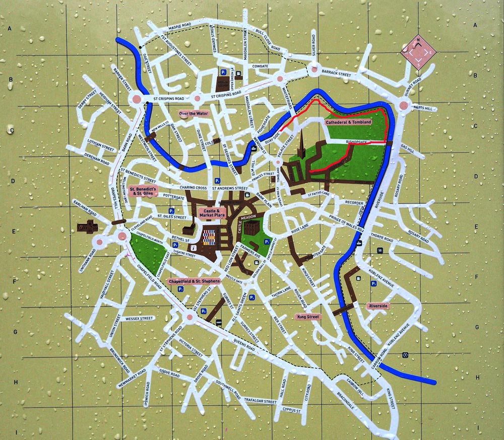
On leaving the beautiful Norwich cathedral we discovered that the rain had stopped so decided to take the opportunity to have a short walk along the riverside (red route). Once essential for transport and industry this meandering river sadly, like many riversides in many towns and cities, had become neglected and undervalued. Since 2007 it is part of a regeneration process to raise awareness of the value of the river and provide access to it for the public. The route is full of historical and architectural interest and should be a major tourist attraction.
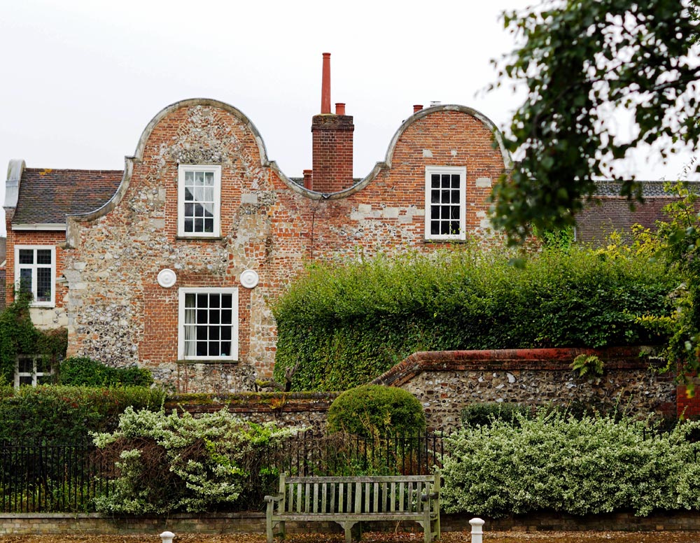
 We headed towards the river along The Close passing a lovely Dutch gabled house opposite the Cathedral Herb Garden, which we nipped in to for a look, and then along Hook’s Walk with its excellent brick and flint-built houses, many rendered and colour-washed which in turn leads to the curiously named Gooseberry Garden Walk.
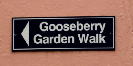
I had hoped that this lane would pass through some lovely cottage gardens, but instead it has high brick walls and what could have been playing fields at either side and possibly an allotment area.


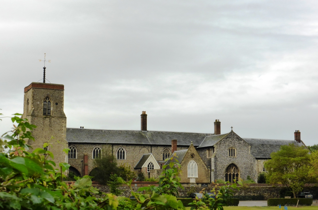
This exits onto Bishopgate opposite St Helen’s Church and St Helen’s House which is now combined with the Great Hospital, founded in 1249 by Bishop Walter de Suffield, and today a complex for the elderly. The original Master’s House, Chaplains’ House, and St Helen’s House, have been converted into comfortable, well-appointed flats. Cottages in traditional almshouse style, but with modern interiors, have been built in the grounds, and a 20 bedded Residential Care Home provides a supportive environment for frailer residents.
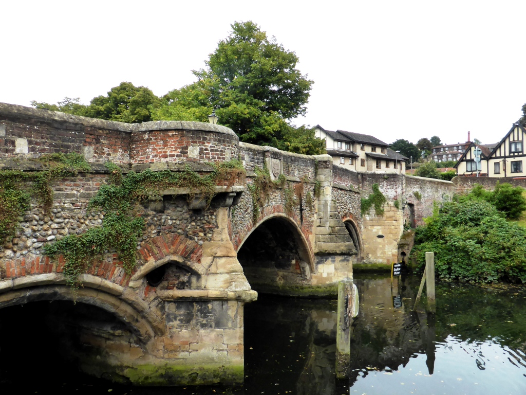
At the bottom of this road you will arrive at the river. Bishop’s Bridge is the first stone bridge to be constructed in Norwich and the only surviving medieval bridge, built in 1340. This was part of the city’s defensive walls, originally with three fortified arches and a large gatehouse at the western end. The stone bridge is predated by an older timber bridge.
Turn left here by the Red Lion pub, without crossing the bridge, and follow the riverside path. Standing on the north easterly tip of what used to be known as Cowsholm, at a bend in the river Wensum is an ancient structure commonly known as the Cow Tower. The name probably originates from the 11th century when the area was a marshy cow pasture. It was originally built as a toll house where monks would take a fee from merchants who wanted to proceed upstream. Later it became what must have been a very grim prison before ownership finally transferred to the City in a ruinous state at the end of the 14th century. It was completely rebuilt in 1390 when it was known as the Dungeon.


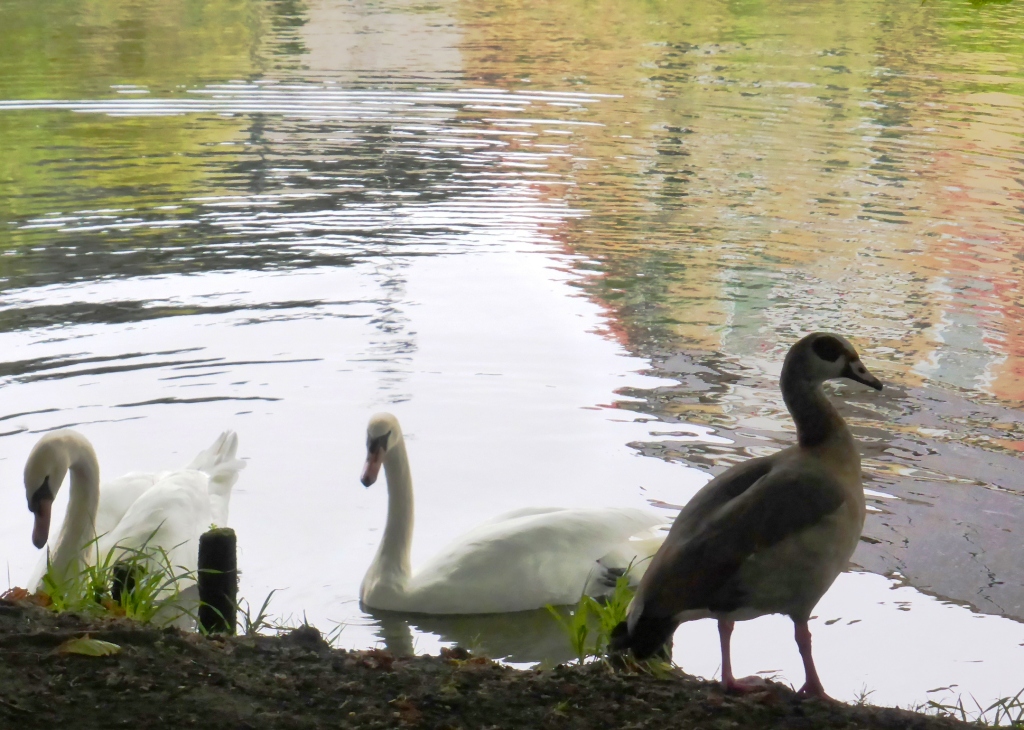
A little further on is Swan by Amelia Hawkins. The markings were based on a scroll identifying swans which hangs in the Great Hospital. The plaque is installed on the sluice for the swan breeding pit, which is set further back at right angles in the grounds of the Great Hospital. This Grade II listed medieval swan breeding pit in the Great Hospital Meadow is the only such structure left in the whole of the UK. Constructed in 1793 as a purpose built confined area, the swan pit contained the hospital’s cygnets, to be fattened on grain and sold for the table.

On the north side of the river Wensum stands St James Mill, draped in Virginia Creeper, which was built in 1836 in an attempt to regenerate the local yarn industry by The Norwich Yarn Company. It has had a variety of uses including Caleys chocolate manufacturers for their box and cracker department in 1904 and in 1918 it was sold to become a Government Instructional Factory where those injured in the First World War were taught skills such as carpentry, bricklaying, plastering and tailoring to enable them to reintegrate into society. Today it houses Jarrolds headquarters and training centre along with a number of other businesses and the John Jarrold Printing Museum.

Next you will see the Jarrold’s Footbridge or Peter’s Bridge which opened in January 2012 and is named after the former Jarrolds chairman Peter Jarrold. The vision behind it goes back about 20 years. Peter Jarrold, then chairman of Jarrold & Sons Ltd, thought that an additional pedestrian bridge would open up the access from the city centre to Mousehold Heath, to the north-east of the city. But it was only when Jarrold’s former printing factory site was about to be developed, that the bridge became a reality. The building of the J-shaped bridge became part of the conditions for the development, and it was constructed using a combination of weathering steel and timber and designed to give the impression of a smooth arc over the river below.

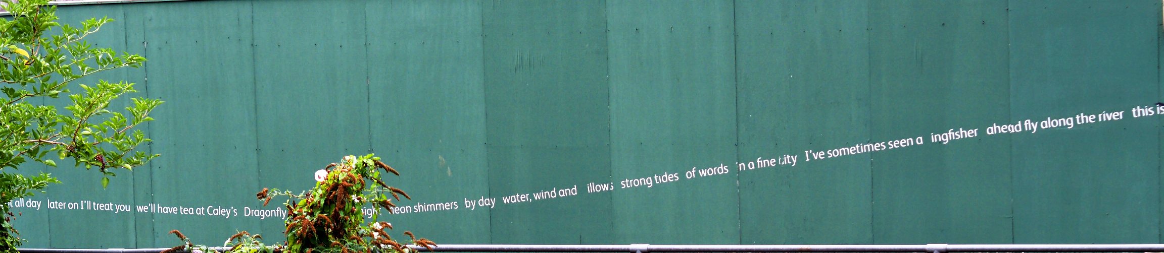
Beyond the printing works, a renga – a word map created by means of an ancient Japanese tradition of shared writing – strings a snake of words and phrases along green hoardings beside the river. A Renga for St James was created here on site in 2009. It was conceived by Alec Finlay and Cath Campbell as a poem to describe the character of the location. It is composed of linked verses on many different themes – including history, topography, everyday life, economy and ecology and utilises the local Norwich vernacular and reference points.
Weeping willows drape gently over the river on the far side drawing the eye along the river bank and to the next impressive bridge.

Whitefriars Bridge was opened in 1925 with the first bridge on this site dating back to 1106 when it was known as St. Martins Bridge. The original timber bridge was swept away in a flood during the 13th century. This was rebuilt and lasted until the mid 16th century when the Earl of Warwick ordered its destruction to prevent the rebels, led by Robert Kett and protesting against the land enclosures, from entering the city. It was eventually rebuilt as a stone structure in 1591 and this lasted until the start of the 20th century when it had to be pulled down due to river widening, and replaced by the present bridge.

Attractive apartments line the river here, opposite the Quayside where an attractive development with diverse architectural styles has been created. And another unusual art installation.

Quayside Bales by Les Bicknell. An installation of 31 ‘bales’ unevenly spaced along the full stretch of the quayside commemorating the area’s past. The ‘bales’ represent packages discharged from barges, while the names celebrate local businesses and the lives of some of the people who lived and worked at Quayside up to 200 years ago.
And if you would like to find out more about the public sculptures in Norwich/Norfolk/Suffolk then the Recording Archives is a good place to look. They also have sculpture trails on their site. Or there is an excellent map on the Sculpture for Norwich website.

The current Fye Bridge, by the side of the Ribs of Beef pub, was constructed in 1933 but records of a bridge on this site date back to 1132 with evidence of a crossing point during Saxon times. The site is supposedly the location of a medieval ducking stool used to determine if a woman was a witch.

This is the point where my camera battery died. But it was about time to return to Tombland (not as one might expect to mean a place of the dead, but in fact Old English for ’empty land’ and this was the site of Norwich’s Anglo-Saxon market before the Normans came and shifted it to its present position next to St Peter Mancroft Church) and the Park ‘n Ride bus back to the car park and home to the 17th century Kings Head in Bawburgh where an excellent dinner awaited.

30 thoughts on “Norwich Part III: Wensum riverside walk”
Comments are closed.