Norwich Part I: History and Architecture

Norwich was founded by the Saxon North Folk (“North Folk” became “Norfolk”) at the confluence of the Yare and Wensum rivers sometime around the 6th century.

My first visit to Norwich and it rained. After days of unseasonable heat and blue skies in early September the forecast for the Saturday that we intended to visit the county capital of Norfolk was sadly correct. But since the main attraction was the cathedral it didn’t deter us and in fact it worked out rather well. I am going to split the posts up otherwise they would be far too long and photo heavy, so posts about the cathedral itself may be a while down the line.

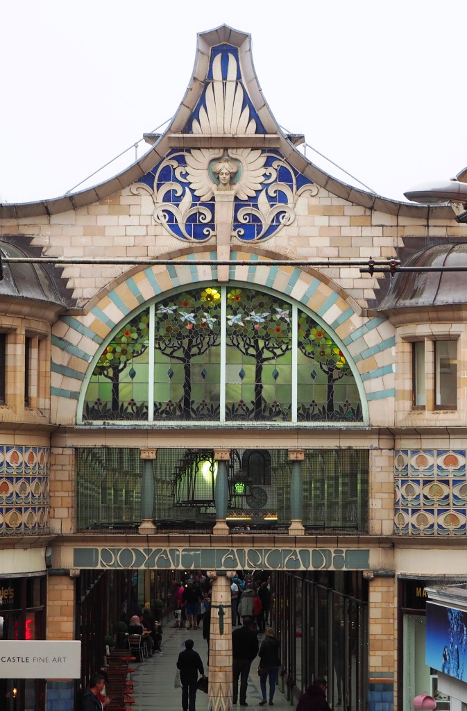
Today we are going to walk through the city from the bus station to the cathedral. We left the car at Thickthorn Park ‘n Ride and took the bus into the city centre as we had no idea of where to park in the city. It proved to be a good idea. The first destination was the information office at the Forum so we could pick up a map or two! Getting there was a bit tricky though, as we took a wrong turning, but imagine my delight when we found ourselves outside the delightful Art Nouveau Royal Arcade which was one of my ‘must see’ sights.

OLYMPUS DIGITAL CAMERA

Exiting the arcade we discovered the market place; the City Hall, the Guildhall and the church of St Peter Mancroft.

Market Place
Market Place
Guildhall
Guildhall

Continue reading Norwich Part I: History and Architecture

Scrobbesbyrig/Shrewsbury: Town Trail Part 1

Today we are going to follow the blue path around town, starting from the Bear Steps (1) heading to the railway station. (The churches, station and library appear in ‘Looking at stone buildings)

towntrailmap (Trail 1)

The Bear Steps (1) is in the centre of town and named after a pub that was opposite the steps.

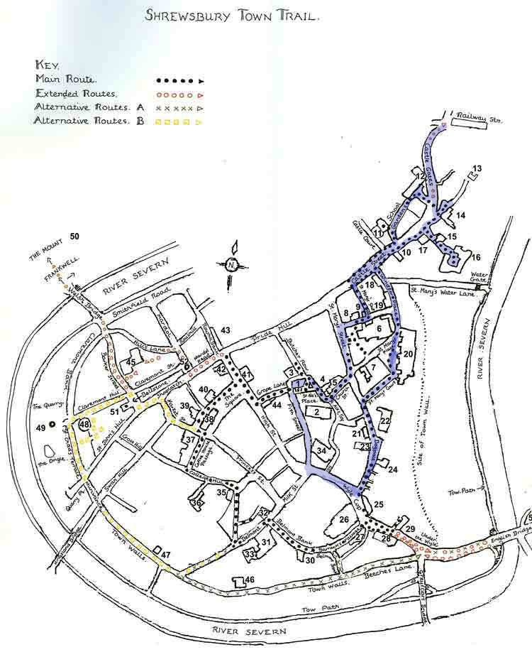
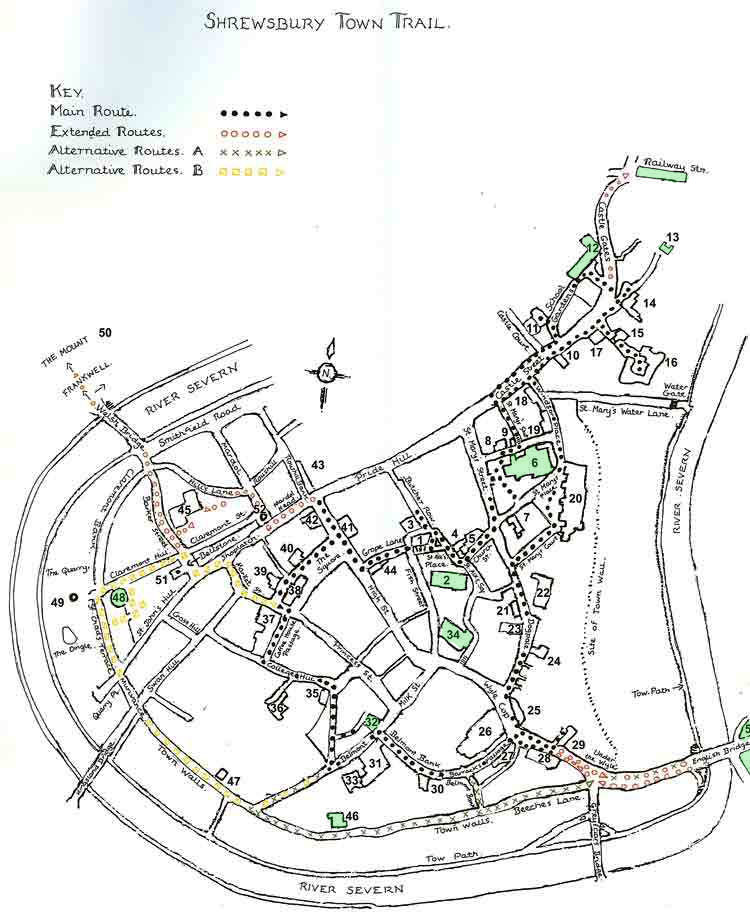
This place has a family connection as the OH’s eldest uncle was born in one of the small cottages back in 1913. The Bear Steps hall is one of only a few remaining medieval stone and timber-framed halls that dominated the town’s architecture. It now houses the offices of the Shrewsbury Civic Society (who produce a Shrewsbury Town Trail booklet and from which much of this information has been gathered) an Art Gallery and Coffee Shop. Continue reading Scrobbesbyrig/Shrewsbury: Town Trail Part 1

Scrobbesbyrig/Shrewsbury: A look at stone buildings

Although I lived in Shewsbury for two years at the beginning of the millennium, and relocated to south Shropshire from Surrey in 2011 I have not written much about the county town. I do have rather a large number of photos though taken over several years from various visits and since it has quite an interesting history, including buildings of various designs and styles built over a thousand years, I thought it time to set this right.

The first written evidence that refers to Shrewsbury dates back to 901. It refers to Shrewsbury as ‘Scrobbesbyrig’ which indicates that it was then a fortified settlement with ‘Scrobbes’ most likely referring to a scrub covered hill, and ‘bryig’ suggesting the presence of fortifications. Shrewsbury is a stunning historic town with over 660 listed buildings and some very strange street names – Dogpole and Mardol, Gullet Passage and Grope Lane. And there is still disagreement as to whether the modern-day name is pronounced Shrewsbury, or Shrowsbury.

Shropshire is England’s largest inland county with Shrewsbury as the county town. Curled up within a horseshoe bend of the River Severn (Great Britain’s longest river), it narrowly escapes being an island.

towntrailmap (stone)

A thriving Saxon town it had a mint by the early 900s and following the Norman Conquest, a castle and a monastery. By the 1380s Shrewsbury was the third largest centre after London and York. The town’s heart still remains within the embrace of the river, protected and rich in ancient streets and historic buildings. Continue reading Scrobbesbyrig/Shrewsbury: A look at stone buildings

St Just in Penwith

St Just in Penwith, shaped by its industrial mining past, is the most westerly town in England and began as a medieval settlement called Lafrowda. It is surrounded by dramatic landscapes of wild moorland, wind-shaped carns and Bronze Age remains. The town made its fortune from tin and the marks left by the boom of the mid-1800s still dominate. There are two squares – Bank (with its 1931 clock tower) which was the business centre (and where the miners would have collected their wages) and Market where the shops and pubs are located (and where the miners would have spent their wages).

Market Square
Bank Square

The grass amphitheatre behind the clock tower is Plen-an-Gwary (Old Cornish for ‘playing place’) where Miracle plays would have been performed 500 years ago. In more recent times it has been used to stage the full cycle again in 2004 and also to hold the Gorsedd, an important Cornish festival. Continue reading St Just in Penwith

New Zealand Wrap-up #2

Sailing

Auckland is the largest city in New Zealand with a population of 1.4 million and the greatest concentration of Polynesians in the Pacific. It is known as the ‘City of Sails’ and it is thought that 1 in 3 people own some form of watercraft.

DSCF9483

“Latin skies upon Chinese lagoons

tousled, sunny-mouthed, sandy-legged coast”

~ Poet Allen Curnow

Ultimate Holiday

DSCF9305

Ruapuke Beach is reached via a winding dirt-road that snakes its way through native New Zealand bush and lush green rolling hills beneath the foothills of Mount Karioi, an extinct volcano that watches over the town of Raglan.

The black volcanic sand is so hot that when the waves come in steam rises! Surfers ride the waves. the only ones we have seen along the coast today. Rock pools are a rich source of photographic inspiration; tiny crabs scurrying one way then another in the shallow pools, a red crab hiding under a rock, green and shiny mussels, black barnacles, starfish waiting for the tide to turn, shiny seaweed drying on the rocks. Black sand.

In the Country

Waikato is dairy country. The green rolling hills are home to cattle and wild flowers. And views.

Arts and Crafts

P1170990
Left-hand waves at Manu Beach

Raglan is home to many artists who produce original art, carvings, jewellery and other handicrafts. Shopping here can be an expensive pastime!

P1170987

Te Parapara Garden

DSCF9932

In pre-European times there were many gardens on the banks of the Waikato River. Te Parapara takes its name from a pa that was located on the site of Hamilton Gardens. This garden illustrates Maori horticultural traditions and technologies.

Maori horticulture is closely connected to  spiritual beliefs. Gardens and gardening practices have ritual aspects. The carved figures on the palisades (pouwhakarae) represent specific ancestral figures.

This brings me to the end of my New Zealand adventures. I have only seen a tiny portion of these amazing islands, but what I have seen has impressed me. A lot. I will be back…