The Manly Eastern Hill Heritage Trail

Manly is named after the Aboriginal people first encountered on the shores of Port Jackson in 1788. Due to its remoteness from Sydney it was not developed by Europeans until the mid-nineteenth century when a ferry service was introduced. Over the subsequent years Manly has undergone countless changes in its environment. Fortunately there are many fascinating buildings and parks that have been retained and the Heritage trails have been created to take visitors from the harbour beaches into the centre to appreciate Manly’s history.

DSCF7709

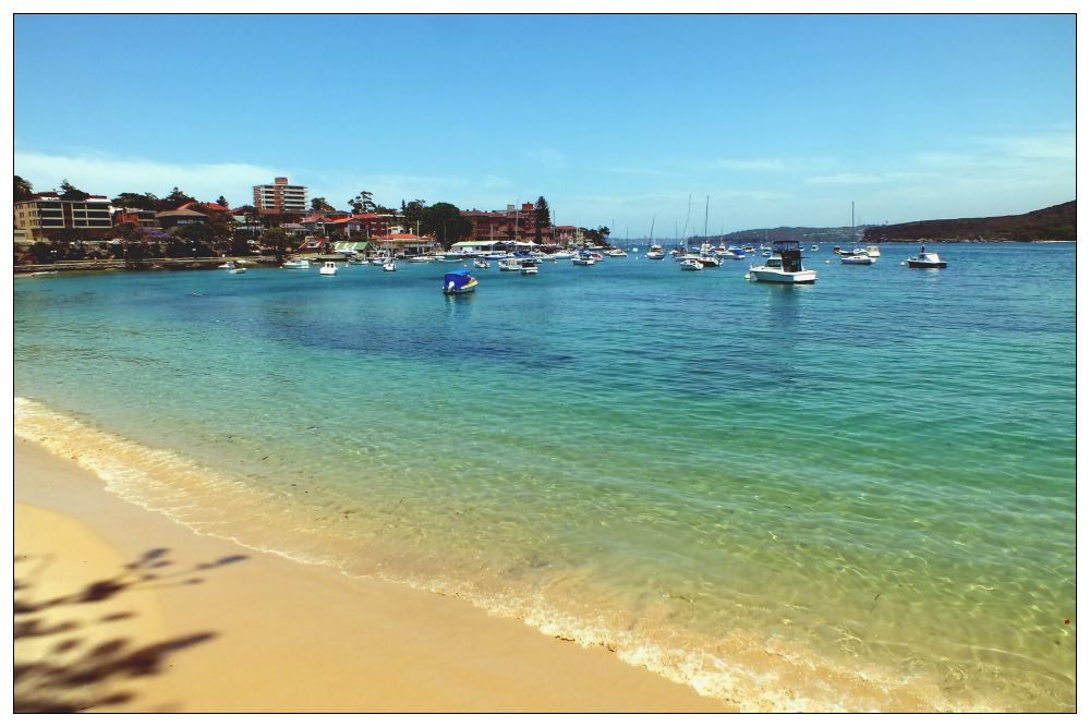
I started on this trail from the East Esplanade on a very hot day in November. Under a large Moreton Bay fig tree is an interesting plaque that informs you about the first inhabitants of the Manly area who were the Aborigines known as the Kayimai. They lived as hunter-gatherers, roaming according to the seasonal availability of food and trading with other clans. They moved around, making shelter as needed from branches and fronds or using the many sandstone caves in the area.

Following the path around the corner you find the Manly Cove Launch Club, established in 1937. Next to it stands the heritage-listed Manly Rowing and Sailing Club Boatshed. Established in 1875, this was one of the earliest waterside clubs in NSW. Carry on up the steps and right on East Esplanade to the corner of Stuart Street. Walk up Stuart Street to the junction with Addison Road, the second road to your right.

DSCF7735

Addison Road Architecture

The road has been planted with an avenue of Norfolk Island Pines and mixed with Port Jackson Fig trees (smaller than the Moreton Bay fig) and was first planted in 1882. It provided the most welcoming shade on this hot day as I wandered down the road peering over fences to look at the homes.

DSCF7737

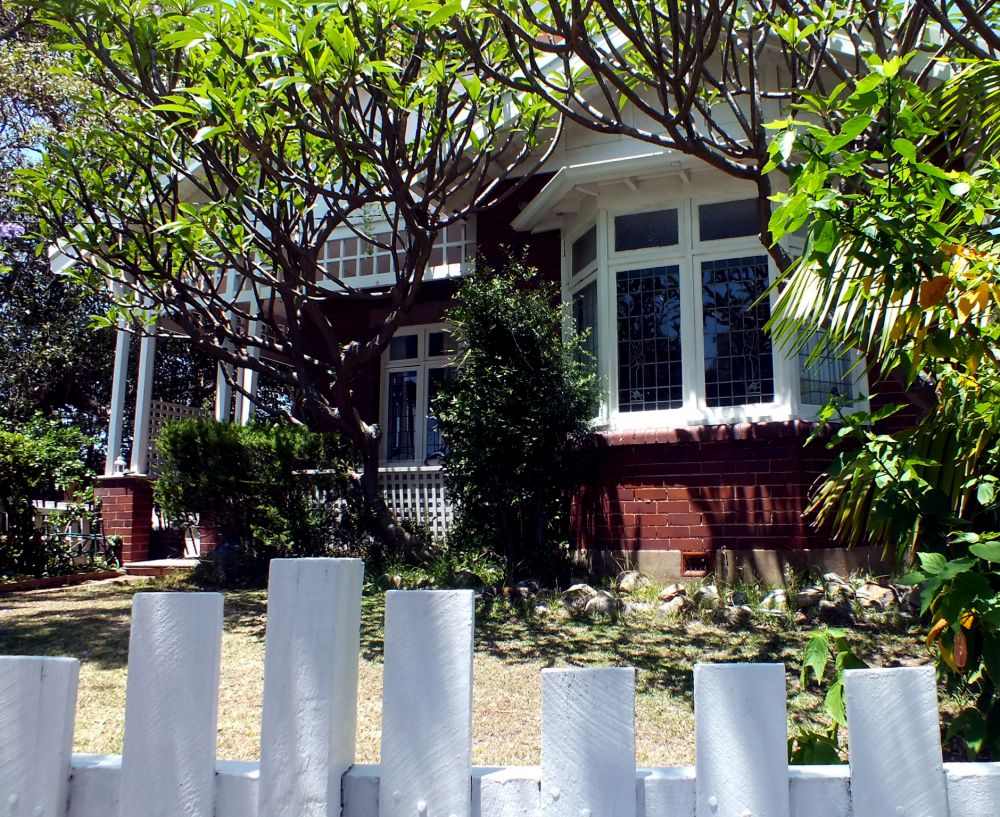
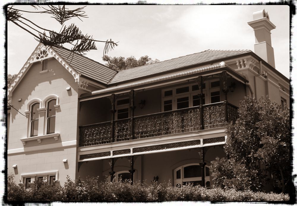
Here are some excellent examples of different styles and periods of architecture. There are Italianate, Victorian Villa, Federation, Interwar Spanish Mission, Old English, Californian Bungalow, Post-war International, Late Twentieth Century, and Post-modern architectural styles! I’m not expert enough to be able to identify them, but I do know that there are several very interesting features that I admire.

Could this be an example of Post-war International?

DSCF7775

Federation Style, maybe?

At the end of Addison is a path onto Manly Point ‘Peace Park’, an area now a Little Penguin Critical Habitat. A plaque close by reads:

“World peace begins in the hearts and minds of each individual – may we each seek harmony and peace in our daily lives. “

Peace Park View

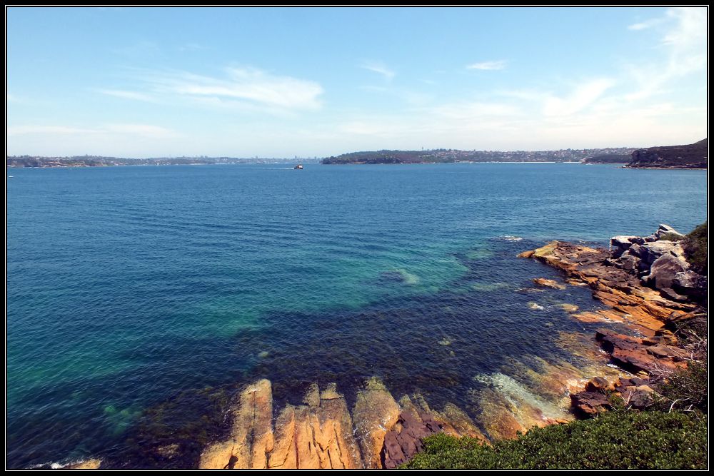
A couple of metal benches provide a resting place with a view over to the Quarantine Station and across the bay to Middle and South Head and where I sat and watched the Manly ferries pass by. Even if you are not interested in architecture it is still worth walking to the end of this road for the views.

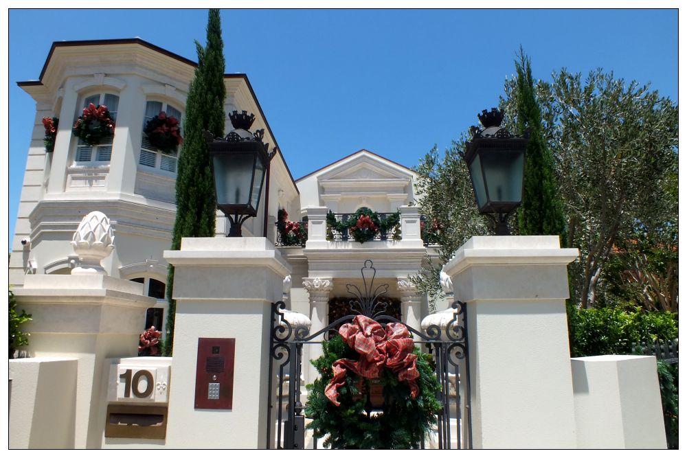
Retracing my steps I passed this imposing white building which was dressed for Christmas with beautifully designer wreaths and ribbons.

DSCF7744

The grey and white decoration on this house (California Bungalow?) is perfectly framed by this wonderful gum tree with its peeling grey bark revealing a chalk-white trunk. Even the white lilies match. And just look at that fretwork above the windows!

DSCF7740

And this one has interesting gables and windows. Lots of straight lines going on here.

DSCF7789

I’d love to see inside some of these houses.

DSCF7783

Returning to Stuart Street I turned right, then right again into Craig Avenue for Little Manly Beach. Here I walked along the beach to the Kiosk where I could get a much-needed drink, and decide where I went from here. My intention was to continue to Little Manly Point and follow the trail around Spring Cove to Collins Beach and possibly visit the Old Quarantine Station, but given the soaring temperature and the fact that storm clouds were fast appearing on the horizon, I decided to cut across Marshall Street (this area of Manly reminds me of San Francisco with all the steep hills).

Observe the chimney pots on this house on Marshall Street and the lovely 3D bargeboard on the gable end. Not to mention that wonderfully scrolled wrought-iron balcony and the arched windows.

DSCF7824

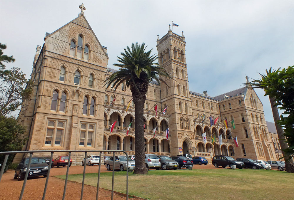
I cut through the grounds of St Patrick’s (the International College of Management, Sydney is now located in the former St Patrick’s Seminary) and down several sets of steps which brought me out onto College Street.

ICMS
The ICMS building – formerly St Patrick’s Seminary

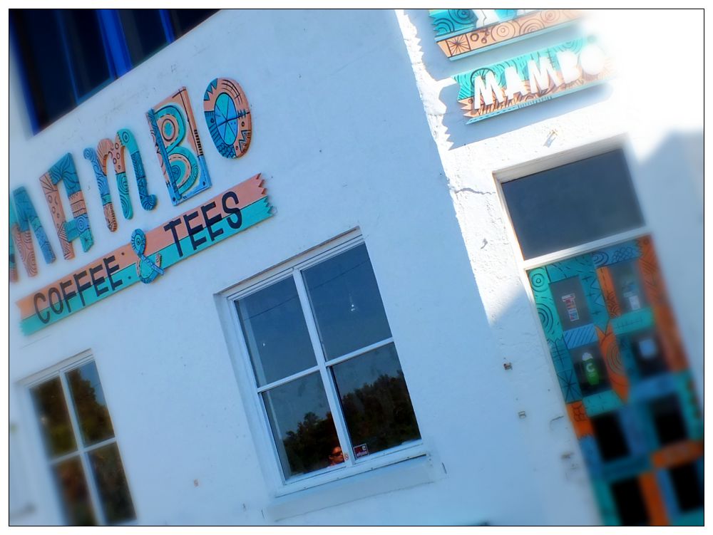
From there it was an easy stroll down Bower Lane to Marine Parade near the swimming pool and Mambo Coffee shop and make my way back to the esplanade. Just before the storm broke!

Mambo
Mambo

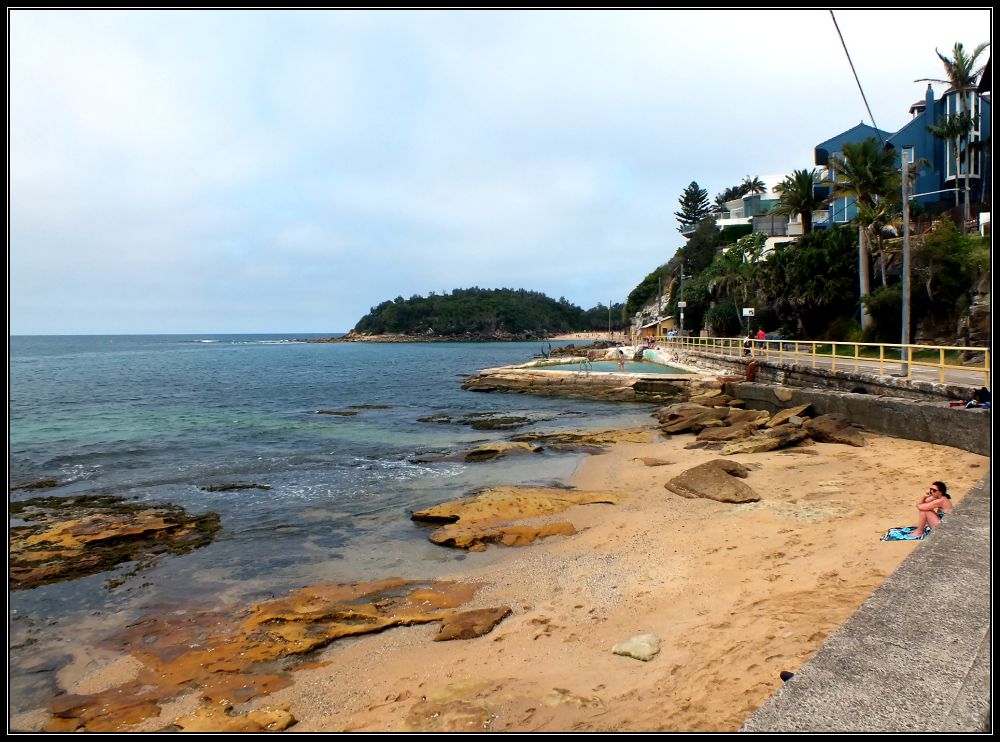
This blue house (below right) overlooking Cabbage Tree Bay and in spitting distance of Shelly Beach is my dream house. Location, location, location!!

Marine Parade
Marine Parade
blue house
A better view

I noticed some very interesting windows along this route:

Leaded with stained glass
Leaded windows with stained glass

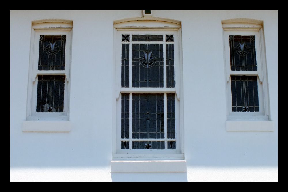
When walking an historical trail like this one it is important to pay attention to the details you see along the way. That might be a picket-fence post, a barge-board, a colourful tile, an interestingly shaped window, or some stained glass or gable ends.

…and maybe there are some Australians (or architects) out there who can help me to identify the different styles.

Wintery Blues

Following a thread posted on my visit to Stonehenge I noticed that I had commented on my Avebury  post that I still had to have a look at a local stone circle in Shropshire: Mitchell’s Fold Stones. That comment was made in March 2014.

9
Yes that is snow on the lens…

So on Saturday, in bright sunshine I decided to take the shortish drive (25 miles) to find these stones. As we turned off the road and approached White Grit (Powys) the covering of snow on the lane alerted me to the fact that maybe this was not such a good idea.

4
I need a vehicle like this one!

Continuing up the lane to the car park with the ice/skid light illuminating on my dashboard I hoped that I would be able to turn around at the end. Reversing down this track was not really an option. The sun was still shining, though there was an ominous black cloud in my rear mirror.

As with many prehistoric sites Mitchell’s Fold is subject of legend. It is said that a fairy gave a magic cow in times of famine which produced an endless supply of milk. An evil witch tried to milk her into a sieve, and realising the trick the cow disappeared. The witch was turned into a stone and a circle of stones was built to ensure she could not escape.

The stone circle is not too far from the parking area, but the temperature was somewhere around 2°C and the wind was raw. The landscape (that which was still visible) looked amazing. Wrapping up in scarves and gloves and hiking boots we headed up towards the stones, which were sadly hidden in the blizzard that then hit us!

2

I tried – honest I did, but I can’t say that this was my best photographic venture despite risking frostbite.

Oh, well, I will try again in the summer – this vista is well-worth exploring, stones or no stones! And there are barrows and cairns in the area too.

6

(This stone circle was constructed in the Bronze Age, over 3,000 years ago, using dolerite stones from Stapeley Hill. Today there are 15 stones arranged in a rough circle, but there may have been as many as 30).

If you enjoy a walk, long or short, then have a look at Jo’s site where you are welcome to join in.

R G Menzies Evening Walk

During my trip to Australia I managed to have a couple of days in Canberra, Australia’s capital city, though many people think that it is Sydney. Canberra gets a bad deal I think, from a tourism POV, mainly because it is full of politicians and museums! But the attraction for me (apart from having a granddaughter living there), is the chance to wander around the many galleries and museums scattered around the lovely Lake Burley Griffin, named after Walter Burley Griffin, the American architect who won the competition to design the city of Canberra.

DSCF8513

On our arrival in the city, my son and I stretched our legs by walking a short distance around the lake and enjoying the early evening sunshine. We parked at one end of the R G Menzies Walk and set off towards the National Carillon. You can see it in the distance, situated on Aspen Island.

 ‘I cannot honestly say that I liked Canberra very much; it was to me a place of exile; but I soon began to realize that the decision had been taken, that Canberra was and would continue to be the capital of the nation, and that it was therefore imperative to make it a worthy capital; something that the Australian people would come to admire and respect; something that would be a focal point for national pride and sentiment. Once I had converted myself to this faith, I became an apostle …’

Sir Robert Menzies – Senate Select Committee Report,
‘Development of Canberra’, September 1955

DSCF8538

The R.G. Menzies Walk was named in acknowledgement of Sir Robert Menzies’ crucial contribution to the development of the nation’s capital, Canberra. During his second term as Prime Minister (1949–66), he committed his government to the task of creating a capital worthy of the nation.

DSCF8506

The Captain Cook Memorial Globe uses meridians of longitude and parallels of latitude to form an open-cage globe, with landmasses depicted in beaten bas-relief copper. The three routes of Cook’s voyages, with explanations of ports of call, are inscribed on the surrounding handrail.

DSCF8515

At the Nerang Pool we wandered away from the lakeside path and into the bush and marshland around the pool where we viewed wonderfully clear reflections of the white gum trees in the early evening light, found some stepping-stones leading to a ‘waterfall’, wandered past a pretty ‘Smoke Tree’ and watched a colony of rabbits nibbling at the lawns.

Looping back onto the lakeside path we came across a statue of Menzies on the foreshore and a convenient bench to sit and admire the view across the lake to the National Library, Questacon, National Gallery and the Kings Avenue Bridge.

DSCF8517 The path is used by walkers, joggers, cyclists and skateboarders, so watch out when taking photos or you might lose a limb! If you look carefully at the duck photo you will see that the female leading her chicks back to the grass is hissing at a passing cyclist. The light was truly lovely at this time of the day with lengthening shadows and golden light.

This walk is only about 5 km return and took us about an hour and a half. It is easy-going, being quite flat and most of the route is accessible by wheelchair. There are many other interesting things to see on this side of the lake including statues, sculptures and memorials and also the National Bonsai and Penjing Collection, and it is the site of the annual Floriade, a major flower festival held each spring. (And those of you who know me know how much I’d love to be here then!)

DSCF8574

[The lake is nine kilometres long and the lakeshore is 40.5 kilometres in length. Yass-Canberra was chosen as the site for the national capital on 8 October 1908. The city owes its origins to an international design competition won in 1912 by the American architect, Walter Burley Griffin. Today, Canberra is known as one of the world’s great planned national capitals, along with Washington DC, Ottawa and Brasilia.]

If you enjoy a walk, long or short, then have a look at Jo’s site where you are welcome to join in.

Hills Road Walk

I have still got a few posts left in me about my travels at the end of last year – feels odd writing that as I haven’t yet acclimatised to being back in the UK. I keep expecting to see my grandson having breakfast, or being able to go for a walk along a beach. Sigh!

One reason for visiting New Zealand was to meet my son’s partner’s family and in particular, her parents who live in the delightful surfing town of Raglan on the black sands of the west coast of the South Island, about 2 hours south of Auckland. This is the Waikato region; a landscape formed by volcanoes creating a lush, fertile green pastoral heaven. It is no wonder that Peter Jackson picked this region for the home of the Hobbits (Matamata).

Raglan is overlooked by Mount Karioi in the Pirongia forest park, an extinct volcano. Although it would have been amazing to trek into the forest and among the Podocarps, such as rimu and totara which are found at lower altitudes, along with tawa and tree-ferns, the weather was against us, being too wet a lot of the time. I did manage a short walk along Hills Road, where the ‘in-laws’ live, with views towards Mount Karioi and Whaingaroa Harbour. Join me on this walk and enjoy the wonderful views all around in this picturesque part of the country.

DSCF9144
Mount Karioi in the background

DSCF9176

If you enjoy a walk, short or long, then you may enjoy visiting Jo’s Monday Walk where you are in for a treat.

Clovelly Beach to Bondi

I began this popular cliff-top walk from Clovelly after taking a bus from the city (#339 ) to Clovelly beach. Walking down past a little cafe, the Seasalt Café and Kiosk, and public toilets which overlook the beach brings you to a footpath and the beach. A group of males were frolicking in the water in their budgy-smugglers, not sure who they are but they certainly had a few muscles between them 🙂

DSCF7322

Budgie Smugglers

The walk from Clovelly to Bondi is about 4 km but there are quite a lot of steps and stairs on this route. Clovelly beach is a popular swimming and snorkelling spot and home to a fish called the blue grouper that is affectionately protected by the locals.

My first stop was at Waverley cemetery which may boast the world’s most scenic location.

Then on to Bronte beach. The ocean pool is very popular with children as is the sea-themed playground.

DSCF7474

The path continues across the beach to Tamarama nicknamed by locals as Glamarama because of the bronzed and buffed bodies to be found there. En route you pass crumbling apartment blocks and multimillion dollar mansions.

Continuing along the very interesting sandstone cliffs sculptured by the sea and wind, you reach Mackenzies Point where there is a well-placed lookout point.

DSCF7531

The coastal path then continues down to the Bondi Icebergs Club, so called because members swim all year round in its saltwater pool. Climbing up the last of the steps brings you to the southern end of Bondi’s beach and a bus ride back to the city.

DSCF7565

This is a classic Sydney beach experience. Think stunning ocean views, invigorating salt air and the opportunity to cool off in the salt water pools along the way.

DSCF7602

If you enjoy a walk, short or long, then you may enjoy visiting Jo’s Monday Walk where you are in for a treat.