Walking in an artist’s footsteps

Whilst in Essex and with time to spare between checking out of one place and checking in to another, we decided to visit the quintessential English Dedham Valley on the borders of Essex and Suffolk where Constable drew inspiration for some of his paintings, notably “The Hay Wain“.

“The sound of water escaping from Mill dams …, willows, old rotten banks, slimy posts and brickwork. I love such things … as long as I do paint I shall never cease to paint such places.”

~ John Constable

The scene is rural England at its most romantic and although the spot which inspired him has altered slightly you can find the easily recognisable view at Flatford. The area is charming; narrow lanes lead to hamlets and meadows and there are plenty of riverside walks along the River Stour which meanders through this enchanting valley. Dedham, East Bergholt and Flatford is affectionatley known as ‘Constable Country’ and you can see examples of his work and information about the man at the National Trust exhibition centre located at Flatford.

OLYMPUS DIGITAL CAMERA

Continue reading Walking in an artist’s footsteps

A brief look at Colchester

We were in Colchester at the beginning of September for a wedding so didn’t really do much in the way of exploring. Given my love for architectural styles I did have a brief wander around the Cultural area where we were staying to see what I could find.  It is of course a very old Roman town (Camulodunum ) and once the capital of Roman Britain, but was attacked and destroyed during Boudica’s rebellion in AD 61.

At only 50 or so miles north of London it is growing fast as a commuter town.

We stayed at the recently opened Greyfriars Hotel on the eastern edge of the High Street.  It is not only a beautiful C18th neo-classical building, but was for a hundred years a much-loved icon of educational excellence and, even centuries before 1755 when the current house was built, its site had religious, social and educational significance. Occupants have included friars, nuns, householders, clergy, physicians, horticulturists, an industrialist and students (young and adult). Empty from 2007 when sold by Essex County Council who decided it was no longer fit for purpose for education the building has been transformed.

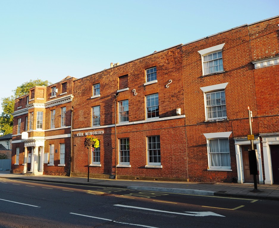
The wedding we were attending was held across the road in the Minories – another lovely Georgian building and now an art gallery and centre for post-graduate study in art. This house in a very similar style to Grey Friars was bought in 1731 by Isaac Boggis a merchant in the wool trade.

OLYMPUS DIGITAL CAMERA

Continuing along the High Street you reach Castle Park and another neo-classical designed Georgian house – Hollytrees – which was built in 1718 by Thomas Blagden for Elizabeth Cornelisen. It was completed by March 1719 but unfortunately Elizabeth passed away before she had the chance to live in it. It is now a museum (free entry) and forms the eastern part of Castle Park. Continue reading A brief look at Colchester

Scrobbesbyrig/Shrewsbury: Town Trail Part 2

towntrailmap (Trail 2)

Leave Bear Steps on Fish Street (1) via Grope Lane to exit onto the High Street. On the corner is the former Cross Keys Inn. (44)

Bear Steps

(The medieval folk were quite apt to call ‘a spade a spade’, or in this instance, the heart of the red-light district was called Grope Lane (ahem… shortened from something even more unacceptable). These areas were often found in the centre of market towns, such as Shrewsbury, to  please the visiting market tradesmen who came to the town and whose stalls were close by, as well as the locals. St Alkmund’s Place was used for the market until the thirteenth century. Most towns have renamed their streets to something more genteel, such as Grove or Grape or Grave – you get the picture. Shrewsbury has retained its name, but then with names like Mardol and Dogpole you can sort of see why!)

The High Street

Opposite is the Square. From here you can see several important buildings: Owen’s Mansion (41),  the former Plough Inn (40), Wolley’s House (39), the Old Market Hall (38), the former Music Hall (37), and the very interesting Alliance Assurance Company with its Flemish styled ornate building of pink banded brick and grey stone. Look at the top of this building and you will see the loggerheads (leopards or lions) the Salop coat of arms. Continue reading Scrobbesbyrig/Shrewsbury: Town Trail Part 2

Monthly Photo Challenge: Frosty January

I was beginning to think I would never get any frost or snow photos of Ludlow. The last time I saw a really hard hoar-frost was several years ago. Then on Wednesday I awoke to a beautiful softly coloured sunrise – and frost!

DSCF3744

Not only was there a hard frost, but also fog diffusing light. An ideal time to grab the camera and wander down by the river.

Date: January 20 2016
Weather: cold, freezing fog, but sunny
Temperature: Cold (0°C)
Time: 13:20 – 14:25 PM

Excited by the thought that I might find some rime ice on leaves and trees I first went down to the river by the Mill Weir, where I hoped to get a view of the river and the trees along the Breadwalk. Because the sun was coming from my left, the trees were in darkness with just a glimmer of gold on my side of the river. Continue reading Monthly Photo Challenge: Frosty January

Scrobbesbyrig/Shrewsbury: A look at stone buildings

Although I lived in Shewsbury for two years at the beginning of the millennium, and relocated to south Shropshire from Surrey in 2011 I have not written much about the county town. I do have rather a large number of photos though taken over several years from various visits and since it has quite an interesting history, including buildings of various designs and styles built over a thousand years, I thought it time to set this right.

The first written evidence that refers to Shrewsbury dates back to 901. It refers to Shrewsbury as ‘Scrobbesbyrig’ which indicates that it was then a fortified settlement with ‘Scrobbes’ most likely referring to a scrub covered hill, and ‘bryig’ suggesting the presence of fortifications. Shrewsbury is a stunning historic town with over 660 listed buildings and some very strange street names – Dogpole and Mardol, Gullet Passage and Grope Lane. And there is still disagreement as to whether the modern-day name is pronounced Shrewsbury, or Shrowsbury.

Shropshire is England’s largest inland county with Shrewsbury as the county town. Curled up within a horseshoe bend of the River Severn (Great Britain’s longest river), it narrowly escapes being an island.

towntrailmap (stone)

A thriving Saxon town it had a mint by the early 900s and following the Norman Conquest, a castle and a monastery. By the 1380s Shrewsbury was the third largest centre after London and York. The town’s heart still remains within the embrace of the river, protected and rich in ancient streets and historic buildings. Continue reading Scrobbesbyrig/Shrewsbury: A look at stone buildings